
A day trip from the city
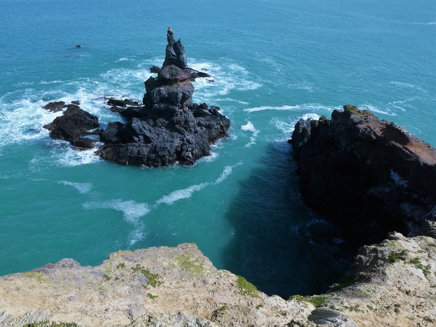
On a fine early spring day, we set out to explore an area we had not visited for about 10 years. Boaz Rock Stack, on Banks Peninsula, sits between Tumbledown Bay and Te Oka Bay. It is a pile of rocks stacked up at the end of a short headland with high cliffs, tumultuous waters, nesting birds, and seal colonies.

We drive from Christchurch to Lyttelton via the road tunnel and skirt around the edge of the harbour before turning off to the south and through the narrow gap of Gebbies Pass. The area is strewn with rocks worthy of rock climbing, popular with cyclists, and sits below the towering crater rim of the Port Hills to the west and the peninsula hills on the east.

A steep and winding road
We arrive at the small settlement of Little River on the main road to the peninsula’s main town of Akaroa – a harbour town and former French colony and enjoy a short stop before again turning south.


A steep winding road takes us up through farmland and bush to the summit and the Southern Bays Road. The views are breathtaking as we come out of the native bush and arrive at the ‘T’ intersection which branches east and west.

From here we can see right over the flat Canterbury Plains to the Southern Alps which form the backbone of the South Island. They are snow-capped, steep, and stunning. The Ellesmere and smaller Forsyth lakes, sit far below along the coastline, trapped from the Pacific Ocean by sediment and sandbanks.

A haven for wildlife and birds, Lake Ellesmere is, in fact, a shallow lagoon, broad and held in from the ocean by a long spit. The indigenous Māori name is Te Waihora (meaning spreading waters) and holds special cultural and historical significance. An old railway line, now long abandoned, has been transformed into a ‘rail trail’ and cycling exponents can be seen bracing themselves against the strong winds, or gently cycling along on a warm summers day.
The heady narrow path
Banks Peninsula is an amazing place and it takes time to explore this small area. Roads, walking tracks, and trails are to be found all over this amazing outcrop of land. We drive down one of the roads towards the bays, visible from the high road, passing sheep farms and native bush.

Spring lambs stay close to their mothers’ sides as we drive by.

We pass a surfing beach, drive over a headland, and park the car. We take a short walk down the road, through a gate placed in the fence beside an old fishing pole to mark the way, and across the green field towards the cliff tops.

As we carefully pick our way along this rather narrow track on the cliff top, birds coming and going from their nests, the sun is warm and the breeze is light.


The narrow track makes me feel slightly heady as I think to myself, ‘I hope this path is stable’; recollecting the big earthquakes that struck the city of Christchurch and surrounding countryside in 2011. At times I do not feel so safe as we find our way along the cliff edge towards the rocky outcrop of Boaz Rock Stack; yet, this headiness is also somewhat exciting as I peek below at the swirling ocean and jagged rocks.


A unique picnic spot
We marvel at the scene around and below us as we find a lunch spot more than halfway down the cliff and with Boaz at eye level, approx 100ft (30 metres) across the swirling current of the ocean.


With the warm sun on our backs, we spend a couple of hours enjoying being with nature – watching the birds glide into the nests then flap furiously as they head out to find more food for the nesting females and young ones.


It is a delightful surprise to see a seal climb out of the water and bounce its way up the ‘stack’ to bask in the sun. Another seal frolics and fishes in the nearby waters and we eagerly watch the waves to see it jump out and dive down in different spots on its fishing expedition.

Changing tides and energetic waves
As we relax at our lunch spot, the tide changes, the sea becomes more powerful as the larger waves crash against the rock walls and race back towards the ocean and forcefully merge with the next incoming wave. It is like watching a game as the waves crash against one another and form another new wave.

The water between our vantage point and the rock stack becomes ‘rougher’ and more dangerous. We look back towards the inlet as the waves in the bay became more ‘pronounced’ and suitable for the surfing fraternity awaiting their next ‘perfect wave’.

Soon, it is time to pack up our picnic and retrace our steps. We turn to take a last look before driving back through the farms and native bush towards Little River for coffee and cake en route home.

Topography
There are many amazing photographs of Banks Peninsula showing the bays, headlands, and steep hills that form this archipelago jutting out from the flatlands of Canterbury in the east of the South Island of New Zealand. It extends 30 miles (48km) into the Pacific Ocean with the sweep of the wide Pegasus Bay to the north and the aforementioned Lake Ellesmere to the south. The Peninsula’s land area is about 500 square miles (1,300 square kms) and at its highest point, Herbert Peak sits at about 3,012 feet (918m). Check out the map of Banks Peninsula here: Google map of Banks Peninsula
Geological history
Between 6-11 million years ago a series of violent and massive volcanic eruptions took place on the two overlapping volcanic cones and Banks Peninsula was formed. As the land eroded to half its height, deep valleys and high headlands formed. As part of this process, about 6,000 years ago, water flooded the area creating what is now known as Akaroa and Lyttleton harbours from the existing deep valleys. Many smaller harbours dot the uneven coastline of this circular archipelago providing shelter for farming. These stunning bays, such as Port Levy, Little Akaloa, Okains Bay, Pidgeon Bay and Le Bons Bay, with good road access, provide a playground for surfing, boating, camping, rest and relaxation for the avid holidaymakers who make their way to ‘The Peninsula’ in summer.

Although at one time considered an island, the sediments of the nearby Waimakariri river meant Banks Peninsula was actually joined to the mainland. First visited by Captain James Cook in 1770, said to be the first European to visit New Zealand’s ‘Land of the long white cloud’, it was named after Sir Joseph Banks, British explorer and naturalist. Almost 40 years later, in 1809, the early ‘sealer’ Captain Chase saw Captain Cook’s charting error, that due to the low lying Canterbury plains disappearing below the horizon, he realised how Cook had made this mistake. Banks Peninsula was first surveyed by John Stokes in 1850. A little more history – read here
In the 1830’s due to significantly reduced seal numbers and the rapid decline of the ‘sealing’ industry, whalers occupied the Peninsula. Later, it was unceremoniously stripped of its native bush forest as the agricultural industry took over. Today, sheep and cattle farms still occupy a large area of the land; however, New Zealanders are well known for their creative ability to diversify and there is or has been, industry such as Protea farms, vineyards, olive groves, lavender farms, and a cheese factory to name a few. Fortunately, a reasonably sized area is officially protected and has been reforested in native trees.

Hiking trails
The Banks Peninsula walking track is very popular for its scenery and quaint cottage accommodation – a good income earner for the farmers whose land the track in on. Parts of the walk take you through native bush, along the headlands and on down through steep gullies. Read about the walk here
At times, the walk goes by the ocean’s protected bays and although it is more than 20 years since I walked it my memories are fresh and clear. One little hut I stayed in had a small but old wooden fence and garden adorned with hollyhocks and thyme, an old bicycle leaned against the wall in decoration. A dear friend has painted that photo many times selling the paintings to those who fell in love with the cottage just by its canvas view.

#bankspeninsula #boazstackrock #tumbledownbay #littleriver #bankspeninsulatrack #travelthesouth #adayonthepeninsula #teresatraveller #newzealandtravel #travelnz
Hi.
Great recount of this part of Banks Peninsula.
FYI
Lyttelton is the correct spelling
Oh thankyou, John, I will find the typo and correct it… Thankyou for reading my webpages of travel and for suggesting the correction. kind regards Teresa