

Setting out: The Amazing Journey
In July 2020, our friend Liwen, who is studying in Auckland, came to visit Manfred and I for a winter break. Liwen and her husband Geoff, who come from Taiwan, had previously traveled in New Zealand. On this occasion, we talked about a plan to do ‘a roadie’ to the deep South.
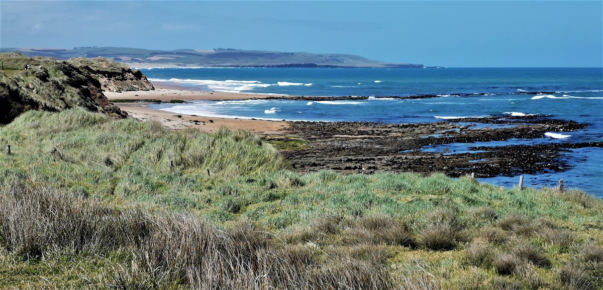
So, on a nice day in mid November we set out on a carefully constructed 10 day ‘Southern Sojourn’. Arriving in the township of Moeraki, on the east coast of Otago, we settled into our cute ‘olde world’ cottage accommodation.

Following a nice walk on the cliffs overlooking the town we enjoyed the view over the bay and watched the storm clouds gathering on the hills of the western horizon.

Moeraki
That evening we enjoyed a delicious dinner at the world renowned ‘Fleur’s’ restaurant. Fleur has a great track record of owning ‘pubs’ and restaurants in the Otago region and has won accolades from Rick Stein and other notable international chefs.


We retired to our cottage and I read the history… The owner’s grandfather, James Findlay, left Scotland in 1896 at the age of 28 years bound for Hobart, Australia. Instead, he left the ship somewhere on the East Otago coast and walked to Moeraki where he purchased land, including that on which the cottage is built. He became a fisherman and a ‘remittance man with a good brain’, and for 27 years he lived alone in the house. At the age of 50, he married Mary, a widow with several children who lived close-by. Eventually they had two boys one of whom was the father of the current owner. He would not have power in the house and lived there until 1947 before entering a rest home in Dunedin where he died soon after.
Moeraki’s history dates back to pre European settlement whereby visits were made by nomadic seasonal Māori tribes and coastal voyagers for trade or war. Known at the time as ‘Onekakara’, Moeraki was settled on Boxing Day 1836 and within a couple of years became a large whaling station, surviving this way for several years.

The population declined then rose again with the age of cropping and farming. By 1890, this little town had become a popular tourist destination for day trippers and holidaymakers. In 1888, salt water baths were opened with 3000 people attending on that great opening day.

The sea eventually breached its walls and the baths fell into disrepair. Fishing took over from whaling and today, along with tourism, it forms an industry that keeps this little town interesting and welcoming.


Moeraki Peninsula and Katiki Point
Nearby, 4ks over an unsealed road on the headland of the Moeraki Peninsula at Katiki Point, is a lighthouse near where the Ngāi Tahu Māori community had long ago settled. The lighthouse was established and ‘first lit’ on the 22 April 1878. The last lighthouse keeper was withdrawn in 1975 when automation took over. Alongside is the fur seal colony, little blue penguins, and the yellow eyed penguin sanctuary. A popular tourist destination, the penguins are fast becoming extinct and the need to protect them is abundantly important.

Moeraki Boulders
Along the picturesque sweeping coastline to the north are the ‘Moeraki Boulders’ a phenomenon of myth and legend of baskets and food from a wrecked canoe. Scientifically they are described as being created by the action of the sea over 60 million years when most of the North Otago coastline was predominantly under the sea. Some rocks have been known to have contained the bones of dinosaur and extinct sea reptiles. This area is easily visible from the township and the hills above. A walking track takes you along the beach and cliffs to the boulders or you can take a 5 minute car drive to the café and walk a short track down to the beach.
Penguins, sea lions and bird colonies
The following morning we rose early to catch a glimpse of the penguins—we were lucky to see one pop out of the water and waddle up the cliff stopping to clean its wings along the way. There were many seals and sea lions, colonies of nesting birds, ‘sooty shearwaters’, and ‘white fronted storm petrels’.


Yellow eyed penguin just out of the water
The Catlins

Soon we were on the road again. Passing through Dunedin, as the rain clouds loomed on the southern horizon, we drove towards ‘The Catlins’. By the time we turned off the main road at Balclutha and wound our way toward the wild south eastern coast, the rain and wind had arrived in force. At Kaka Point, a pretty village on the coast with golden yellow sand and wide windswept beaches leading to the lighthouse walk at Nugget Point, we stopped to enjoy the rugged southern beauty.

We certainly did not see this area in its best light (the sun had sadly disappeared!) and were unable to even get out of the car to do the walk to the lighthouse due to the strength of the gathering wind and rain.
Tahakopa Bay, Papatowai & Purakanui Falls
Continuing down the wild coastline, we wended our way inland before arriving again at the coast in Tahakopa Bay at Papatowai where we would stay for 3 nights to explore the surrounding area. We felt like we had entered a different world here in ‘The Catlins’, away from everywhere and anywhere. It felt good.

Our little cottage was decked out with surfboards hanging from the ceiling and a day bed alcove surrounded by large windows to make the best of the garden view.


Tuis visited the garden to feed from the flax flowers and rabbits hopped across the lawn. We relaxed. We made plans for the coming days and hoped the inclement weather would clear so we could enjoy what was on offer in an area we knew had amazing scenery, great native bush, and plenty of other surprises.


Tui (front and back view) and Kereru in the trees at the Papatowai cottage
The next morning the weather showed promise of improvement and we walked up to the main road to visit the local coffee ‘caravan’ and iconic ‘bus’ called The Lost Gypsy. We enjoyed the coffee and the ‘yummy’ homemade muffin as we observed the clearing weather.


Early in the afternoon we drove to the Purakanui Falls Scenic Reserve about 30 minutes from Papatowai. Our destination was a beautiful 15-20 minute walk along a narrow path deep into the podacarp and beech forest to the Purakaunui Falls. We arrived at the top of the falls and enjoyed the view down the river as it followed a narrow passage in the Purakaunui River that fell away over three widening tiers to a pool at the bottom 20m (66 ft) below.


After enjoying the view, the sounds of water falling away, and the birds in the bush, we followed the rather steep narrow track down to the lower platform and marvelled again at the stunning view. The Purakaunui Falls are well photographed and famous enough to be used on postage stamps.


More rain came and went but we managed to avoid getting very wet during our explorations. We settled back into our little cottage and enjoyed the twilight drinking tea, watching the Tuis and rabbits while cooking dinner, chatting, and relaxing. The tide in the estuary of the Tahakopa River came and went creating an ever changing vista adding to the ambience of the stay.


Catlins waterfalls and beach walks
The following day we explored another area of native forest along the Southern Scenic Highway with further beautiful, but quite different, waterfalls, for which this area has several. The Matai and Horseshoe falls are a 30 minute return walk rising above a small carpark.

You can do the return trip the same way or take a walk along the old abandoned Catlins rail line which takes about 1 hour. Enjoying the nature of the regenerating forest, the smell of the bush and wet earth, the fantails and other native birds which flit in and out of the trees, we arrived at the viewing platform. We enjoyed the full rushing waterfalls, after the recent rain, before making our way back to the carpark.


Back at the cottage, in the mid afternoon, Liwen and I went for an exploratory walk down to the beach of the river mouth and around the point. We came back along a bush track called Picnic Point Track and arrived at the cottage just before another shower of rain.


Beautiful Beaches, Bays, Lighthouses and Petrified Forest

The following day dawned dry and sunny and we anticipated our onward journey down the coast towards Invercargill, New Zealand’s southern most city. But before getting there, let’s do some sightseeing along the way. We drove along the Chaslands Highway, a continuation of the Southern Scenic Highway overlooking lush farmland and beautiful long sweeping beaches; and then inland through the forests where we crossed the boundary from Otago into Southland. Our first planned destination was a short drive off the main road and down to what is on the maps called ‘Porpoise Bay’, but known to the local Southlanders as Curio Bay.

The sweep of the bay provides stunning golden white sand within the shelter of the Curio Bay Cliffs which provide amazing photographic opportunities. On the south side of the cliffs is the 180 million year old ‘petrified forest’.

This ancient forest has turned into rock over millions of years. The https://southlandnz.com/the-catlins/curio-bay website has this to say, which succinctly epitomises the Jurassic nature of this forest:
‘The highlight of Curio Bay (Tumu Toka) is watching the outgoing tide reveal a 180 million year old Jurassic fossil forest – one of only three such accessible fossil forests in the world. Millions of years ago the Curio Bay area was part of the eastern margin of the ancient super continent Gondwanaland. The forest was destroyed multiple times by massive sheet floods of volcanic debris; growing back only to be covered again. These events are clearly recorded by distinct bands of fossils in the now exposed cliff face. The erosion of the sea has exposed tree stumps, logs and other fascinating fossils.’

We walked along the path between the native plants and the penguin sanctuary peeking into the viewing windows hoping to catch a glimpse of these amazing creatures—but it was not our day. The path leads to the viewing platform above the petrified forest, and the view was breathtaking.

This area is now a tourist destination and there is a café and small museum within the information centre with samples to inspect and descriptions of the history of the area and how the petrified forest came about.

We climbed down onto the ‘forest’ and felt the stone trees under out feet, inspected these tree stumps and trunks, and marvelled at the whole amazing sea coast.


The Southernmost Point

Sticking to the coastal road, far away from the main highway, we drove on through the green rolling hills and farmland towards the southernmost tip of the South Island. Slope Point is exposed to the vast Southern Ocean and the trees around the area lie towards the horizontal plane. After parking, Liwen and I walked down the track through the sheep and lambs to a signpost marking this Southern point.

The Slope Point signpost 
Liwen at Slope Point with the Great Southern Ocean in the background
Many local and international visitors were enjoying the sunshine and vast view, and we chatted with them as we strolled back to the car enjoying the sunshine and amazingly fresh air.


Waipapa Point


We chose to stay with the coastal road, enjoying the remote beauty of the deep south. Our next stop came was a spur of the moment decision instigated by the beauty of the day and the need for lunch! We drove down a side road to Waipapa Point on the Eastern edge of Toetoes Bay where the lighthouse dominates the landscape. It is a short walk from the carpark to the lighthouse which sits up on a high point, overseeing the sand dunes, rugged coastline, and a plethora of sea mammals.


The area has a colourful maritime history due to the foundering of the passenger ship Tararua in April 1881 on one of its regular runs between Otago and Melbourne via the Southern port of Bluff. Many of the 130 victims are buried in the local cemetery. In response to the shipwreck, the lighthouse was built, lighting up in 1884. It became automated in 1974, updated in 1988, and is still active, protecting the ships travelling along the coastline. On this day, large sea lions and fur seals basked on the flat rocks and sand or moved slowly in the early afternoon sun. Sometimes they fight and play but it is not a good idea to get too close or you may find yourself the subject of the attack!
The end of the Catlins…. but with much more to come…


Liwen by the Tuatara statue by the old museum in Invercargill and an ancient Tuatara in its home
We travelled on towards Fortrose on the edge of the Mataura River mouth, a pretty end to the Catlins part of our Southern Sojourn. We drove on through the farmland towards Invercargill where we stayed overnight. I had previously lived and worked in Invercargill and we had a nice dinner with family and friends before settling in for the night, excited for the next part of our journey.
Please go to the next chapter in this story….. (coming soon)
#southislandnewzealand #curiobay #moeraki #fleursplacemoreaki #travelnewzealand #thecatlins #waipapapointlighthouse #tuatara #tuatarainvercargill #moerakipenguins #petrifiedforestcuriobay #papatowai #katikilighthouse #Moerakipeninsula
Such beautiful sea and views, so many animals, and such a rich journey!
Thankyou Vincent. for taking the time to reply and for the admiration of the story, the animals and the rich journey 🙂