
The journey continues….

A hanging Valley in Doubtful Sound
A trip down memory lane
We drove north out of Invercargill, headed towards Winton, and then west towards Nightcaps, my hometown. It was here I grew up with my family with a backdrop of the ‘The Takitimu Mountains’. Often shrouded in snow and incredibly beautiful, they always draw me ‘home’. I relayed many stories from my past of long summer days, school, family, and history of the area. We visited the house I grew up in and chatted to the owner and his mate who were renovating a part of the house. I checked out the back garden area where dad kept a huge organic garden and large chicken run, and my mind exploded with memories of times now long past.

The original house I grew up in in Nightcaps, under renovation at that time
Time for holiday memories
Driving directly south again we arrived at Riverton, a lovely town at the south sea coast on the Aparima River mouth. Whitebait (a tiny fish delicacy) stands line the river banks and at the bridge we enjoyed the view of the fishing boats lined up in the harbour. These boats work out in the southern ocean and the famous Foveaux Strait, a turbulent stretch of water between the south coast of Southland and Stewart Island, the third and smallest of the main islands of New Zealand. Our favourite restaurant overlooking the sheltered Caroline Bay on the edge of Foveaux Strait was closed, so we bought some delicious, rustic takeaway, local food and sat on a picnic table overlooking the harbour.


We drove past ‘The Rocks’ and Howells Point around to what we have always known as the ‘Riverton Back Bay’. This area is wild, with powerful swells, waves crashing against the giant rocks and huge ‘undertow’ pulling the water back, deep into the strait. We climbed onto the rocks, exposed to the strait, that looked safe and marvelled at the scene of deep green dangerous water below us.

Riverton Back Bay with Stewart Isalnd clearly seen in this day on the horizon
The beautiful rugged Southern Coastline
Moving around the bays beyond Riverton we drove by Colac Bay, a favourite destination for holidaymakers and surfers, past the rugged coastline of several more bays such as ‘Gemstone Beach’ and on towards Te Waewae Bay, locally known as ‘Bluecliffs beach’. Here we stopped at ‘McCrackens Rest’—a signpost on the cliffs above the vast sweep of Te Waewae Bay. On this clear day, the commanding views of the tiny, million years old eroded volcano that forms the Solander Islands were something to behold.
https://southlandnz.com/western-southland/natural-attraction/mccrackens-rest


Liwen and Manfred at ‘McCracken’s Rest’ signpost
Tuatapere and more summer memories
Soon we turned away from the coast and drove through the 10ks to Tuatapere and crossed the river previously known as ‘The mighty Waiau’; although now a mere trickle compared to when I was a kid! Back in those days, our family travelled to this small town to enjoy a New Year’s family day out, at the ‘Tuatapere Sports’, which began right by the river in 1910. Tuatapere has been a logging town since its inception in the 1880s and the ‘paddock’ where the sports were held was cleared of logs and debris. As a kid, we passed through Tuatapere on Southland summer days to go on down to Te Waewae, Bluecliffs Beach gathering seafood—flounder and Toheroa—which, in those days, were prolific but are now limited or banned from collection. I still have clear memories of those days on the beach, with friends and families, and I shared the stories as we drove along. Back then, we would go home from these trips tired, hot, and sun burnt (or suntanned) from the long days outdoors.

Lake Manapouri
Driving on the edge of UNESCO Fiordland
We drove northwards on the picturesque road to Manapouri, past the turn off to Lake Houroko and then Lake Monawai on the edge of the UNESCO World Heritage site of Fiordland, known as Te Wahipounamu (Place of the Greenstone). These are deep, long glacially formed lakes of myth and legend, used for fishing, hunting, boating, power schemes, and the outdoor education centre of Borland Lodge on the fringes of Lake Monawai. I recounted stories of my children’s school camps at Borland and the opportunity they were lucky to have had in this incredibly beautiful remote region of New Zealand, tucked under the Princess Mountains and the Kaherekoau Mountain ranges, which are heavily bush clad and covered in snow much of the year.
https://www.fiordland.org.nz/visit/fiordland-national-park/
Continuing this long adventurous drive, we turned our attention to our destination of Manapouri, and arrived at our delightful accommodation where Manfred and Liwen were soon in the kitchen enjoying a cooking session.


Later, an evening walk down to the Waiau River and the outlet of the Lake we checked out where we would start our trip the next day – an overnight trip on Doubtful Sound also known by its Māori name of Patea. This was a part of the ‘Southern Sojourn’ trip we had been looking forward to since the idea for this journey took hold.

The absolute beauty of Doubtful Sound
Watching the weather
The weather in Fiordland is fickle and a common theme in the area is that one can expect to experience four seasons in one day. We had been monitoring the weather forecast for several days and the promise of nice warm calm weather for Fiordland for the next 24 hours was like food for our souls.
Crossing Lake Manapouri
We boarded the boat that would take us from the lake outlet of the Waiau River across Lake Manapouri, with prolific native bush skirting along the entire coastline.

Setting out across Lake Manapouri
Several small islands in the lake sit silently in the deep blue water and the glacially carved arms run off at odd angles. Hope, South, North, and West arms run deep into the remote mountains surrounding the lake, providing access to hunting and fishing huts. Hidden amongst the bush, the famous Kepler Track runs along the lake edge on the north eastern shore, and I recalled the times I walked that track with friends and family. The sky was clearing as we sailed along and the promise of good weather appeared to be manifesting.
West Arm Manapouri – a little history
Our boat was taking us to the West Arm where the power house for a large electricity plant is situated. The power plant caused much controvery in the 1960s for the potential environmental impact on the local area, the ‘mighty Waiau’ flow, and as far reaching as upsetting the balance of nature in Foveaux Strait. Protesters managed to sway the government to change the plan and a ‘tailrace’ was built that runs the water out into Doubtful Sound. Even so, the flow of the Waiau diminished and, later, a significant algae bloom in Foveaux strait almost eliminated the famous oyster beds destroying an iconic local phenomenon in one season. The oyster beds recovered after a few years but the memories of why it happened linger.

West Arm Power Station
The Wilmot Pass: From West Arm to Doubtful Sound
We arrived at West Arm, and boarded the bus that takes tourists over the Wilmot pass and down into Doubtful Sound to meet our boat for our ‘overnighter’. The 21k road that includes the Wilmot Pass 671m (2201ft) sits in the Matterhorn Mountains, with Mt Wilmot on one side and Mt Mainwaring on the other. It was built in the 1960s to accommodate the movement of the heavy machinery from the sound into the arm which was needed for the power station. The only way to get the machinery in was by boat and then this road. Prior, the only way to get over the pass was by a walking track.

Zoomed photo of part of Doubtful Sound from Wilmot Pass 
Doubtful Sound from Wilmot Pass


On Wilmot Pass
Many of the workers on this project lived on a ship ‘The Wanganella’ anchored in the Sound for many years. We stopped on the top of the pass to admire the breathtaking view down the valley and into the Sound before driving the windy road down to the pontoon on the Sound where we boarded the boat ‘The Fiordland Navigator’ to begin our journey.


On the ‘Fiordland Navigator’ 
On The Sound
And off we sail….
Once on board, with 70 other passengers, we settled in with a bowl of soup to warm us as the crew hoisted the sails and off we went. The sun shone and although the breeze was cool, it was refreshing, and it felt good to be back on the water.

Happy to be on the water
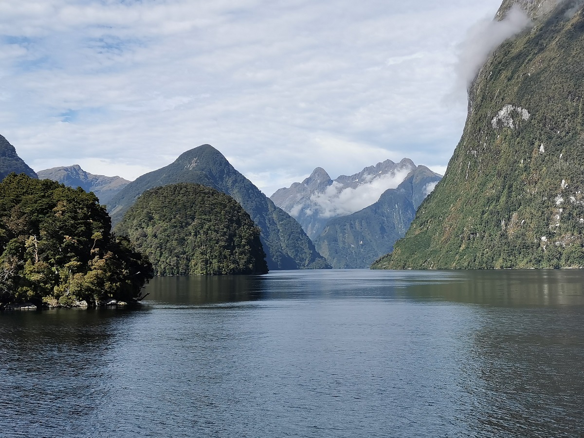
I was last on Doubtful Sound for a day trip about 30 years prior and I easily remembered the beauty, remoteness, and silence of the area. The Sound is actually a fiord, with its U shaped valleys carved out by long term ancient glacial action.

The beauty of Doubtful Sound
We cruised out of the sheltered bay called ‘Deep Cove’ and into the main body of this long deep waterway that leads to the Pacific Ocean 40k (25mi) away. The Sound is not very wide at this point, spreading out towards the open ocean and Secretary Island at the sea entrance. This Sound is the deepest of the South Island fiords being 421m (1381 ft) and was first named Doubtful Harbour by Captain Cook in 1770 who, not knowing the depth, did not venture into the Sound to explore for the safety of his sailing ship. Whalers and settlers renamed it Doubtful Sound.
It contains three main arms all on the south side of the Sound. Hall Arm (8km/5mi) is closest to Deep Cove, Crooked Arm (14km/8.7mi) lies in the middle, and First Arm (6km/3.7mi) is closest to the sea entrance.
Sailing out into the Tasman Sea


We sailed on and, due to the good weather, were able to go outside, past the ‘Hares Ears’ rock island at the south end of the entrance, and enjoy the open sea. The wind blew cold as the boat cut through the rolling waves and picked up speed.


Albatross and other sea birds created a spectacle around the boat as they flew close to the water, rose up into the sky, and dived for fish. Our eyes scoured the water for the whales and dolphins that frequent these waters on their migration journey to the southern ocean or simply like to frolic in the waves of their ocean.


Sometime later, we sailed towards the northern side of the wide entrance and back into the Sound in the shelter of Secretary Island. Nearby are the Nee Islands and the Shelter Islands where we observed fur seals and the Fiordland penguins’ breeding colony.


About Fiordland
The native bush in the whole Sound, and indeed Fiordland, comes right down to the water’s edge, and even under the water there is the presence of black coral which grows prolifically due to the nature of the water in the Sound. The top layer (2-10m/5-35ft) of water has low salinity and high tannins due to the steep run off from the surrounding mountains and discolouration from the native bush. Furthermore this diluted layer is enhanced by the volume of water coming through the tail-race from the Manapouri Power Plant. Below is a warmer layer of undiluted seawater and this contributes to the growth of the black coral (which actually looks white).


Liwen (left) and me (right) kayaking on Doubtful Sound
Kayaking, Sailing and Swimming in Doubtful Sound
Towards the entrance to First Arm many of us were able to enjoy kayaking for quite a distance and then swim in the shelter of the mountains at the end of the arm. The water was cold but refreshing and I was pleased I took ‘the plunge’, even if just to say I did it!


The moody light show
The captain took the boat into Crooked Arm where we were served an amazing dinner comprising several courses with nice wines. We settled in for our overnight on the water in a sheltered bay. The sunset created dancing silver glitters on the black water and it was brilliant to feel the remoteness and quiet of this beautiful place of great nature.

Evening on the water – so relaxing
The beauty and silence of this remote Sound
The following morning we had a nice breakfast and the captain cruised around the Sound taking us close to the flora growing prolifically on the steep sided walls of the mountains. He took the boat deep into Hall Arm and the silent beauty was experienced when the captain turned off the boat’s engines for 10-15 minutes. We were asked not to take photos but just enjoy the nature, the silence, and the heart of Fiordland.


Relaxing as we cruise along
After cruising the Sound for some time and watching the rain come in we docked and disembarked, knowing we had experienced a ‘rare’ day of beautiful weather and an amazing trip on one of the most beautiful places on Mother Earth.

Feel the remoteness

Feel the peace
The return journey to Manapouri
We boarded the bus and returned over Wilmot Pass to West Arm where we again boarded the smaller boat that took us back to Manapouri where the blue skies of the day before were replaced by low dark grey clouds. We felt like we had been away from civilization for much longer than 24 hours.


The Beauty of Doubtful Sound
Queenstown, Cromwell, Naseby & Dansey’s Pass
We drove across the beautiful rolling hills and the ‘red tussock conservation area’ towards Mossburn and Five Rivers, and then to Queenstown where we stayed overnight with my son Eammon and his partner Lucy. The following day we drove through the Kawarau Gorge and Banockburn, past vineyards aplenty with the season’s grape harvest growing on the vines, and down through the Cromwell gorge towards Alexandra.

Lunch at Mt Difficulty Vineyard in the Bannockburn near Cromwell
From here we enjoyed the stunning drive up through the stark landscape of the Ida Valley and into the Maniototo area of Central Otago. The area is famous for the successful gold mining of the 1800s.

The photo says it all
Although the Central Otago Railway Line has since been converted into a rail trail cycling track, the quaint villages attract many holiday makers. Our destination was Naseby, a pretty little town at ‘2000ft above worry level’ in the Larch Forest above the Naseby river where gold mining was plentiful back in the day. Currently, farming, forestry, and winter sports such as ice skating and curling replace the lazy summer holidays of relaxation, mountain biking, hiking, and chilling out in the summer heat. I used to have camping holidays here and it was great to share a little ‘trip down memory lane’ with Manfred and LiWen.

Memories of holidays long ago


We then drove to the Danseys Pass Hotel where we were booked for our last nights stay. This very quaint hotel, tucked into the base of Danseys Pass has an illustrious history providing an inn for the Kyeburn gold diggings, dating back to the very early gold mining days. The area was, in its early years of settlement, called Cows Creek (“Kye” is a Northumbrian term for cows), and was in existence prior to the main gold finds of Naseby in 1861.


The Danseys Pass Hotel is now a popular destination for that nice overnight stay on a fabulous roadie, celebrating that special anniversary, wedding, conference, or just a nice getaway.

Built in 1862 to serve the local gold miners, the stonework was paid for in beer. It has been extended and renovated and has an amazing lounge and dining room bar to enjoy. The accommodation and amenities, both inside and at the outdoor bar, are beautifully maintained to ensure your stay is a memorable one. We enjoyed a lovely meal, sat by the huge lodge style open fire in the lounge, and slept well.

Dansey’s Pass Hotel


On Dansey’s Pass and the road to home
The next day we drove over the beautifully stark tussock landscape of Danseys Pass, named after William Dansey who used this Pass from North Otago to explore the Maniototo.

Dansey’s Pass
The pass sits at 935m (3068 ft) in the Kakanui Ranges. After stopping to admire the expansive view, we drove down into North Otago on our way home to Christchurch.

Dansey’s Pass
We arrived home super satisfied with our amazing trip and with memories we will hold forever. We were so glad we could share this journey with Liwen, who might not have seen these spectacular parts of New Zealand if it were not for our local knowledge and passion for travel.


#doubtfulsound, #fiordland, #fiordlandnavigator, #fiordlandtravel, #newzealand, #southernholiday, #southlandnz, #teresaglobaltravels, #teresatraveller, #thefiordlandnavigator, #travel, #traveltheworld, #traveling, #travelthesouth,
A beautiful story. Felt like I was there with you reliving some great memories!!
Do you remember that first trip…? it was awsum!!
Very eloquently written. Beautiful scenery
Thank you Linda, it is such amazing scenery and unique to our beautiful Fiordland 🙂
I felt clam when reading your trip story. Your writing is like breeze or smell from some amazing place afield full of flowers. Looking forward to see you next story!
Thank you ChiChi, it is wonderful that you enjoyed the story and you wrote your poetic comment which made me smile 🙂 thankyou again
It seems, we share the same enthusiasm for Doubtful Sound. The most powerful silence, I know. The place, which shows us best our relative importance in the world. Greetings
Thank you Andreas.. And yes you are right.. the most powerful silence…. and great observations on our relative importance in this world. thankyou…